Image And Video Annotation for LiDAR Data - Indore
Tuesday, 24 October 2023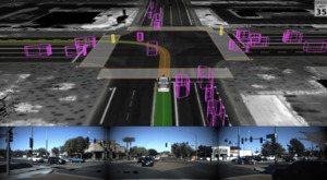


Item details
City:
Indore, Madhya Pradesh
Offer type:
Offer
Item description
Lidar (light detection and ranging) is an optical remote-sensing technique that uses laser light to densely sample the surface of the earth, producing highly accurate x, y, z measurements.Lidar is an active optical sensor that transmits laser beams toward a target while moving through specific survey routes. Lidar can see through objects, such as walls or trees.
Lidar Annotation is performed to train self-driving cars. Lidar annotation is very similar to image labeling in its essence but different in practice for a simple reason: the point cloud is a 3D representation on a flat screen. In addition, humans have to deal with a huge amount of points (in the order of millions) which are not contained by well represented and defined surfaces or boundaries.
At TagX, we understand that annotating data for computer vision models requires a strategic combination of people, process, and technology. In fact, it’s our specialty. If your organization works with Lidar technology, our professionally managed teams of data analysts can help.
Related ads

For More details visit: www.jpinfotech.blogspot.com IEEE 2011 JAVA Project Titles Sl.No.-Project…

OKM EXP 5000-Gold Edition 3D Ground Scanner Metal detector with video eye-glasses The Earth Imagers…
Smile - Picture And Video Collection Project (Delhi)
Do you enjoy taking selfies and don’t mind being in front of the camera? This project is for you…
Ieee 2011 java &. Net in coimbatore (Coimbatore, Tamil Nadu)
J1Online Intrusion Alert Aggregation with Generative Data Stream Modeling. J2Anomaly Detection in…

HTML & CSS - COURSE OVERVIEW Section One: Getting Started 1. Course Introduction 2. Course software…

Sara Kumar, Product Manager at Identiv security video analysis software, shares how video analytics…
Drops: Division And Replication Of Data In Cloud For Optimal Performance & Sec (Coimbatore, Tamil Nadu)
Abstract We propose a new design for large-scale multimedia content protection systems. Our design…

Here are some digital marketing trends everyone needs to know- Artificial Intelligence- AI has…

Final Year Internship Training + Project : Data Science with Machine Learning Attn…

Dear Sir / Madam This gives us great pleasure to offer School Management software with highest…